


Bucknell Voting District, Fairfax County, Virginia
About
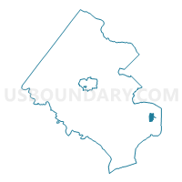
Outline

Summary
| Unique Area Identifier | 681478 |
| Name | Bucknell Voting District |
| County | Fairfax County |
| State | Virginia |
| Area (square miles) | 1.04 |
| Land Area (square miles) | 1.04 |
| Water Area (square miles) | 0.00 |
| % of Land Area | 100.00 |
| % of Water Area | 0.00 |
| Latitude of the Internal Point | 38.76094330 |
| Longtitude of the Internal Point | -77.07684510 |
Maps


Graphs
Select a template below for downloading or customizing gragh for Bucknell Voting District, Fairfax County, Virginia


Neighbors
Neighoring Voting District (by Name) Neighboring Voting District on the Map
- Belle Haven Voting District, Fairfax County, VA
- Groveton Voting District, Fairfax County, VA
- Kirkside Voting District, Fairfax County, VA
- Marlan Voting District, Fairfax County, VA
Top 10 Neighboring County Subdivision (by Population) Neighboring County Subdivision on the Map
Top 10 Neighboring Place (by Population) Neighboring Place on the Map
- Fort Hunt CDP, VA (16,045)
- Hybla Valley CDP, VA (15,801)
- Groveton CDP, VA (14,598)
- Belle Haven CDP, VA (6,518)
Top 10 Neighboring Unified School District (by Population) Neighboring Unified School District on the Map
Top 10 Neighboring State Legislative District Lower Chamber (by Population) Neighboring State Legislative District Lower Chamber on the Map
Top 10 Neighboring State Legislative District Upper Chamber (by Population) Neighboring State Legislative District Upper Chamber on the Map
Top 10 Neighboring 111th Congressional District (by Population) Neighboring 111th Congressional District on the Map
Top 10 Neighboring Census Tract (by Population) Neighboring Census Tract on the Map
- Census Tract 4214, Fairfax County, VA (7,158)
- Census Tract 4215, Fairfax County, VA (7,001)
- Census Tract 4154.01, Fairfax County, VA (5,135)
- Census Tract 4153, Fairfax County, VA (3,763)
- Census Tract 4151, Fairfax County, VA (3,411)
- Census Tract 4154.02, Fairfax County, VA (2,691)